
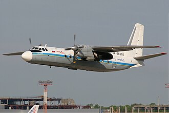
Angara Airlines Flight 2311: Collision with Terrain, Tynda, 2025
On 24 July 2025, an Antonov An-24 operated by Angara Airlines flew into a forested hill while manoeuvring for a second landing attempt at Tynda, in Russia's Amur Oblast. All 48 people on board died. The Interstate Aviation Committee (MAK), which led the inquiry, found that a wrongly referenced altimeter left the crew about 600 metres lower than they believed.
Key facts
| Date | 24 July 2025 |
| Aircraft | Antonov An-24RV, registration RA-47315 |
| Route | Ignatyevo Airport, Blagoveshchensk, to Tynda Airport |
| People on board | 48 (42 passengers, 6 crew) |
| Fatalities | 48 |
| Investigation | Interstate Aviation Committee (MAK); final report published in February 2026 |
Background
The aircraft and the operator
RA-47315 was a twin-turboprop An-24RV built in January 1976. It had served several operators since its days with Aeroflot. At the time of the accident, Angara Airlines operated 10 An-24s, all built between 1972 and 1976. Russia's aviation regulator, Rosaviatsia, said the aircraft had been involved in four incidents since 2018, and officials said it had passed a recent technical inspection. The investigators later reported that its technical condition met requirements.
The people on board
The flight carried 42 passengers, including five children, and six crew. Their ages and experience varied. The captain had nearly 6,000 hours on An-24 and An-26 aircraft, from more than 11,000 hours in total.
Tynda airport
Tynda lies in mountainous country and its airport is about 616 metres above sea level. This matters for the story. Two altimeter settings are in common use. QNH makes the altimeter read height above sea level. QFE makes it read height above the airfield. Tynda's published approach chart for runway 06 uses heights referenced to QFE.
The flight
The aircraft reached Ignatyevo at 08:20 local time and left again at 11:20 after a delay linked to poor weather. The flight was bound for Tynda, a city on the Baikal–Amur railway line.
Near Tynda there was rain and low cloud. The crew flew the BELIM 2A non-precision approach to runway 06, which relies on a radio beacon rather than a glide path. The first approach ended in a missed approach, known as a go-around. The crew then began a second circuit, which includes a turn of about 180° to line up with the runway.
The crew did not report at the next checkpoint. Contact was lost at about 13:00 local time (UTC+10:00, or 03:00 UTC), and no distress call was received. A Rosaviatsia helicopter found the wreckage at about 17:30. It lay on a hillside roughly 16 kilometres from Tynda. There were no roads to the site, so rescuers of more than 100 people cut a path with heavy machinery and reached it at about 23:00.
The investigation
The flight data recorder tape was destroyed by fire, MAK reported on 26 July 2025. The cockpit voice recorder survived and became a key source of evidence.
The preliminary findings, released by Rosaviatsia, described the central problem. The chart called for the crew to pass the beacon at 1,105 metres relative to QFE. The crew told the controller they had passed it at 1,100 metres. However, their altimeter was set to the sea-level QNH. That meant the aircraft was in fact more than 600 metres lower than the crew believed. It continued to descend and struck trees at about 765 metres above sea level, around 150 metres above the airport, while still some 15 kilometres from the runway.
The final report, published in February 2026, listed three main elements:
- The crew did not ensure that the pressure setting they used matched the altitudes they had been assigned.
- The air traffic controller had no instrument means of monitoring the aircraft's height, because the secondary radar at Tynda was out of service. The aircraft's label on the controller's display did not show altitude.
- The crew had switched off the audible alert of the ground-proximity warning system, the device that warns of nearby terrain.
MAK also examined the warning system's behaviour. The final analysis found that its alert began only 3.7 seconds before impact, and that it should have sounded earlier. Investigators asked the system's developer to simulate the final stage of the flight to explain this.
Russia's Investigative Committee, which runs a separate criminal inquiry, reached a consistent picture in January 2026. It said the aircraft was technically sound, the weather allowed a landing without undue risk, and the crew let the aircraft descend far below a safe height.
Aftermath and legacy
Amur Oblast and Khabarovsk Krai declared three days of mourning. The transport minister announced compensation of 5 million roubles for the family of each victim. Leaders from several countries sent condolences.
Scrutiny then turned to the airline. A transport safety inspection reported shortcomings in Angara's work as a maintenance organisation, including paperwork completed without the work being done. On 27 October 2025, Rosaviatsia ordered the revocation of Angara Airlines' operating licence, effective from November.
The accident carries several lessons that apply well beyond one airport:
- An altimeter setting is only as safe as the cross-check behind it. Crews and controllers need to confirm that the reference used matches the chart.
- Where radar cannot show a controller an aircraft's height, the crew's own reports become the only safeguard.
- Terrain warnings protect a crew only if they stay switched on.
- Approaches in mountainous country leave little margin for an error in height.
The investigation's emphasis on setting procedures, ground equipment and warning systems reflects a common theme in controlled flight into terrain accidents. A single small error can pass through several layers of defence when those layers are weakened.